Observation for SeaTac Airport:
Temperature: 27 degrees
Wind: Northeast at 15 knots
Weather: light snow
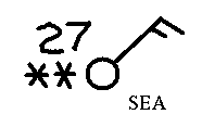
The above observation would be plotted like this:

Note that the wind flag resembles the tail of an arrow pointing in the same direction that the wind is blowing. A long "barb" on the tail of the arrow equals 10 knots, a short "barb" 5 knots. The "stars" to the left of the station indicate snow. The "27" shows the temperature. "SEA" indicates the station is the Seattle-Tacoma (Sea-Tac) Airport.
Note: 1 "knot" means 1 nautical mile per hour and is about 1.15 miles per hour. A nautical mile is one-sixtieth (1/60) of a degree of latitude on a great circle. A nautical mile is used in aviation and marine navigation. A nautical mile is about 6076 feet.
Click here for the symbols used in station plots.
Return to the page asking "Why Did The Air Turn Cold?"