![[Live from Earth and Mars]](../../graphics/mars_map.gif)

The purpose of this exercise is show that it is possible to
locate and measure rocks and other features on the surface
of Mars. Mr. Toad can be viewed in 3-D.
EQUIPMENT
This is an exercise that young students might be able to do
because part of it only requires images, a map base, a protractor, and
a straight edge (or triangle with straight edges).
BACKGROUND
Two Viking spacecraft landed on Mars when Mars was about 363 million
kilometers from Earth (at closest approach, Mars is about 56 million
kilometers from Earth).
Each lander had two cameras separated by 0.822 meters.
The directions or azimuths of the pictures are known
with respect to reference directions for each camera
on the lander.
The map that has been furnished (see note, link, and warning below)
shows a plan view of Viking Lander 2.
If you look carefully at the map, you can see two pairs of concentric
circles with "plus" signs in their centers.
They are labled Camera 1 (left one) and Camera 2 (right one).
The dashed lines extending from the "pluses" are the reference
directions for each camera. The reference direction for Camera 1
extends to the right of the Camera 1 "plus" and the reference
direction for Camera 2 extends to the left of the Camera 2 "plus."
EXERCISE
In the two images below, the sun was toward the left.
This causes the shadows to extend from rocks toward your right.
Picture 21H034/595 was taken with Camera 1. It has a
starting azimuth of 288.5 degrees and an ending azimuth of 298.5 degrees.
Picture 22H033/595 was taken with Camera 2. It has a
starting azimuth of 97.5 degrees and an ending azimuth of 107.5 degrees.
See EXERCISE 3 for procedures for 3-D or stereo-viewing.
Your viewing screen should be 600 or more pixels wide to show these pictures
side by side.
If the pictures don't appear side by side, try increasing the
size of your viewing window.
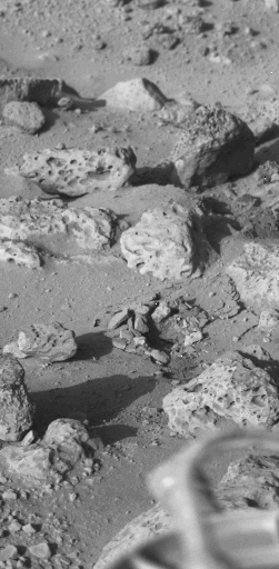
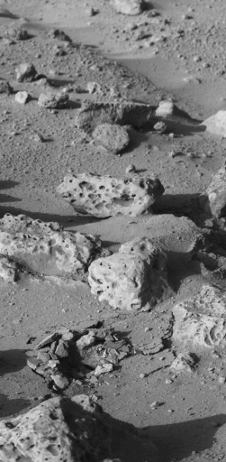
21H034/595 22H033/595
EASY PART
Most explorers have great imaginations.
They often name mountains and peaks for animals,
fictitious characters, or familiar objects.
On Mars, they named a rock for Mr. Toad -- a character in Kenneth Grahame's book
"The Wind in the Willows."
Can you find Mr. Toad in the pictures above?
Once you think you have found Mr. Toad you may use the remaining clues to confirm
your guess.
- The rock is shaped like a toad.
- The rock appears to have warts (like a toad). The "warts" are
shallow pits in the rock.
- Mr. Toad's two bulging eyes are on the left side of the toad (rock).
- Mr. Toad is in the upper half of both pictures.
- Mr. Toad is in the center of the right picture.
- Mr. Toad is in the left-hand side of the left picture.
- Mr. Toad has a mouth. Is he smiling?
- If you can't find Mr. Toad ask your teacher.
- What do you think about locating a small rock on a planet that is
tens to hundreds of million kilometers away from you?
Mr. Toad is a big toad by Earth standards. He is about 25 centimeters long.
This part of finding Mr. Toad involved making a guess (a theorem) and with more
information confirming or revising the theorem.
DIFFICULT PART
Now that you have found Mr. Toad, you can locate him on the map.
To locate Mr. Toad:
- Measure the starting and ending azimuths from the reference direction
in a clockwise direction for each camera and plot a point for each.
Remember:
Picture 21H034/595 was taken with Camera 1. It has a
starting azimuth of 288.5 degrees and an ending azimuth of 298.5 degrees.
Picture 22H033/595 was taken with Camera 2. It has a
starting azimuth of 97.5 degrees and an ending azimuth of 107.5 degrees.
- Draw lines from the "pluses" through the plotted points for each
camera.
- You will get two wedges that extend from the "pluses." These
two wedges include parts of the fields of view of each camera on the map
and are 10 degrees wide.
- The area common to both cameras is where the wedges overlap.
Does the map show a rock labeled Toad in the area overlap?
- Select several points on Mr. Toad which can be identified in each picture.
- Compute the azimuths of these points.
(Interpolate between the starting and ending azimuths of the camera.)
- For each pair of azimuths,
extend the azimuths from the location (+) of the corresponding camera.
These azimuths should cross each other.
- Plot the point of intersection.
Can you find other things this way?
If you had enough time and more pictures, could you make a map of the
rocks on Mars?
(Note. I have included "boltdown angles" in the azimuths given)
Note. The working map that you have on your WEB site, which is linked
below, is a suitable base map. The extended mission map in the back
of Professional Paper 1389
is also suitable. If the map is hard to read and you don't have
Professional Paper 1389, you can request copies of the map from
James E. Tillman or Henry J. Moore.
WARNING:
This section includes a link to the map for this exercise.
Do not click on the link below unless you have a very fast link, a
large memory and a capable system. The biggest, fastest workstations
take about 30 seconds to process and display them.
Lander 2, end extended mission. [Bit Map: 3.48 MBytes]
VERY DIFFICULT PART
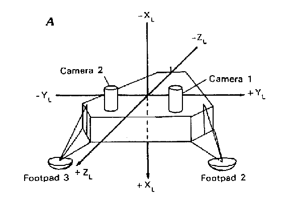
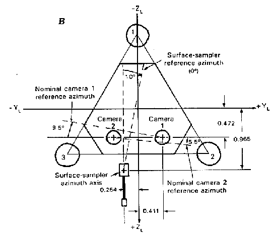
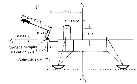
Here are some sketches of a Viking lander. Figure A is a perspective view.
Figure B is a plan view (from the top). Figure C is view from the left side.
You can make your own map of the Viking Lander 2 region shown in the
pictures above using the following information:
- The Lander Science Coordinate System is used for the map.
- The origin is at center of the upper planar surface of the
prismatic lander body. The three axes are perpendicular.
- X is perpendicular to the planar surface and positive downward.
- Y and Z are in the plane of the upper planar surface of the lander body.
- Z is positive in the forward direction.
It passes half-way between the two cameras.
- Y is positive to the left, as viewed from the lander.
- The coordinates of Camera 1 are:
X = -0.487, Z = +0.472, Y = +0.411
- The coordinates of Camera 2 are:
X = -0.487, Z = +0.472, Y = -0.411
In addition, there are Camera Coordinate Systems.
- For both cameras, elevation angles are measured from a plane
passing through the camera mirrors and perpendicular to the azimuth
axes of the cameras. Down is (+) and up is (-).
- Azimuths are measured clockwise from a reference direction.
- The reference directions for Lander 2 with "boltdown" corrections are:
Camera 1 171.37 degrees counterclockwise of +Y
Camera 2 5.45 degrees clockwise of +Y
- Diode displacement corrections are needed for precise work.
If you have questions or problems with the VERY DIFICULT PART contact:
George LeCompte (lecompte@atmos.washington.edu)
3122 Tracyton Beach Road
Bremerton WA 98310
Reference:
Moore, H.J., Hutton, R.E., Clow, G.D., and Spitzer, C.R., 1987,
Physical Properties of the Surface Materials at the Viking Landing Sites on Mars:
U.S Geological Survey Professional Paper 1389, 222p
The data, maps, and text for
this exercise were supplied by:
Dr. Henry John Moore
Scientist Emeritus
Astrogeology Team MS 975
U.S. Geological Survey
345 Middlefield Road
Menlo Park, CA 94025
moore@astmnl.wr.usgs.gov
|
The images, layout, and presentation
for this exercise were supplied by;
James E. Tillman, Research Prof.
(mars@atmos.washington.edu ) and
George F. LeCompte (a volunteer)
Department of Atmospheric Sciences
PO Box 351640
University of Washington
Seattle, WA 98195-1640
|
Copyright: These data, maps and exercises are in the public domain.
Please credit Dr. Moore, Prof. Tillman and Mr. LeCompte.