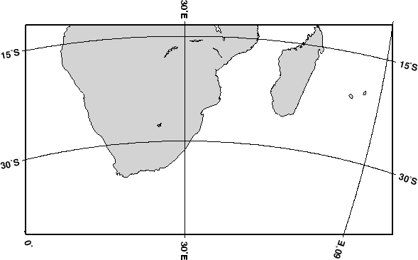
In this mode we define our region by specifying the
longitude/latitude of the lower left and upper right corners
instead of the usual west, east, south, north boundaries.
The reason for specifying our area this way is that for this
and many other projections, lines of equal longitude and
latitude are not straight lines and are thus poor choices for
map boundaries. Instead we require that the map boundaries be
rectangular by defining the corners of a rectangular map boundary.
Using 0![]() E/40
E/40![]() S (lower left) and 60
S (lower left) and 60![]() E/10
E/10![]() S
(upper right) as our corners we try
S
(upper right) as our corners we try
gmtset PLOT_DEGREE_FORMAT ddd:mm:ssF GRID_CROSS_SIZE_PRIMARY 0
pscoast -R0/-40/60/-10r -JA30/-30/4.5i -B30g30/15g15 -Dl -A500 -Glightgray -W0.25p -P > \
    GMT_lambert_az_rect.ps
Note that an ``r'' is appended to the -R option to inform
GMT that the region has been selected using the rectangle
technique, otherwise it would try to decode the values as
west, east, south, north and report an error since
'east' ![]() 'west'.
'west'.