This cylindrical projection was developed in 1745 by C. F.
Cassini for the survey of France. It is occasionally called
Cassini-Soldner since the latter provided the more accurate
mathematical analysis that led to the development of the
ellipsoidal formulae. The projection is neither conformal
nor equal-area, and behaves as a compromise between the two
end-members. The distortion is zero along the central meridian.
It is best suited for mapping regions of north-south extent.
The central meridian, each meridian 90![]() away, and equator
are straight lines; all other meridians and parallels are
complex curves. The requirements to define this projection are:
away, and equator
are straight lines; all other meridians and parallels are
complex curves. The requirements to define this projection are:
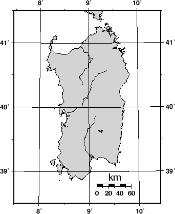
A detailed map of the island of Sardinia centered on the
8![]() 45'E meridian using the Cassini projection can be
obtained by running the command:
45'E meridian using the Cassini projection can be
obtained by running the command:
pscoast -R7:30/38:30/10:30/41:30r -JC8.75/40/2.5i -B1g1f30m -Lf9.5/38.8/40/60 -Dh -Glightgray \
   -W0.25p -Ia/0.5p -P --LABEL_FONT_SIZE=12 > GMT_cassini.ps
As with the previous projections, the user can choose between a rectangular boundary (used here) or a geographical (WESN) boundary.