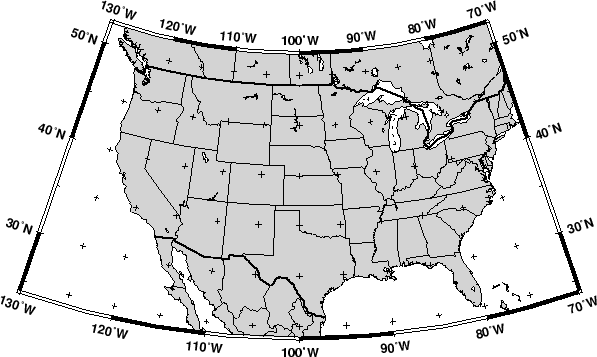
This conic projection was designed by Lambert (1772) and has been used extensively for mapping of regions with predominantly east-west orientation, just like the Albers projection. Unlike the Albers projection, Lambert's conformal projection is not equal-area. The parallels are arcs of circles with a common origin, and meridians are the equally spaced radii of these circles. As with Albers projection, it is only the two standard parallels that are distortion-free. To select this projection in GMT you must provide the same information as for the Albers projection, i.e.
The Lambert conformal projection has been used for basemaps for all
the 48 contiguous States with the two fixed standard parallels
33![]() N and 45
N and 45![]() N. We will generate a map of the continental
USA using these parameters. Note that with all the projections you
have the option of selecting a rectangular border rather than one
defined by meridians and parallels. Here, we choose the regular WESN
region, a ``fancy'' basemap frame, and use degrees west for longitudes.
The generating commands used were
N. We will generate a map of the continental
USA using these parameters. Note that with all the projections you
have the option of selecting a rectangular border rather than one
defined by meridians and parallels. Here, we choose the regular WESN
region, a ``fancy'' basemap frame, and use degrees west for longitudes.
The generating commands used were
gmtset BASEMAP_TYPE FANCY PLOT_DEGREE_FORMAT ddd:mm:ssF GRID_CROSS_SIZE_PRIMARY 0.05i
pscoast -R-130/-70/24/52 -Jl-100/35/33/45/1:50000000 -B10g5 -Dl -N1/1p -N2/0.5p -A500 -Glightgray \
    -W0.25p -P > GMT_lambert_conic.ps
gmtset GRID_CROSS_SIZE_PRIMARY 0
The choice for projection center does not affect the projection but
it indicates which meridian (here 100![]() W) will be vertical on
the map. The standard parallels were originally selected by Adams
to provide a maximum scale error between latitudes 30.5
W) will be vertical on
the map. The standard parallels were originally selected by Adams
to provide a maximum scale error between latitudes 30.5![]() N and
47.5
N and
47.5![]() N of 0.5-1%. Some areas, like Florida, experience scale
errors of up to 2.5%.
N of 0.5-1%. Some areas, like Florida, experience scale
errors of up to 2.5%.