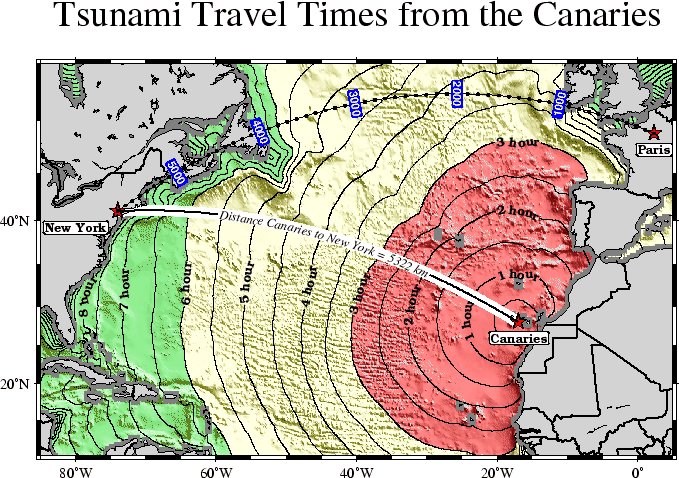
Finally, we will make a more complex composite illustration that uses several of the label placement and label attribute settings discussed in the previous sections. We make a map showing the tsunami travel times (in hours) from a hypothetical catastrophic landslide in the Canary IslandsO.2. We lay down a color map based on the travel times and the shape of the seafloor, and travel time contours with curved labels as well as a few quoted lines. The final script is
R=-R-85/5/10/55
grdgradient topo5.grd -Nt1 -A45 -Gtopo5_int.grd
gmtset PLOT_DEGREE_FORMAT ddd:mm:ssF ANNOT_FONT_SIZE_PRIMARY +9p
project -E74W/41N -C17W/28N -G10 -Q > great_NY_Canaries.d
project -E74W/41N -C2.33/48.87N -G100 -Q > great_NY_Paris.d
km=`echo 17W 28N | mapproject -G74W/41N/k -fg --D_FORMAT=%.0f | cut -f3`
cat << EOF > ttt.cpt
0    lightred    3    lightred
3    lightyellow    6    lightyellow
6    lightgreen    100    lightgreen
EOF
grdimage ttt_atl.grd -Itopo5_int.grd -Cttt.cpt $R -JM5.5i -P -K > GMT_App_O_9.ps
grdcontour ttt_atl.grd -R -J -O -K -C0.5 -A1+u"hour"+v+s8+f17 -GL80W/31N/17W/26N,17W/28N/17W/50N \
    -S2 >> GMT_App_O_9.ps
psxy -R -J -W7p,white great_NY_Canaries.d -O -K  >> GMT_App_O_9.ps
pscoast -R -J -B20f5:."Tsunami Travel Times from the Canaries":WSne -N1/thick -O -K -Glightgray \
    -Wfaint -A500 >> GMT_App_O_9.ps
gmtconvert great_NY_*.d -E | psxy -R -J -O -K -Sa0.15i -Gred -Wthin >> GMT_App_O_9.ps
psxy -R -J -W1p great_NY_Canaries.d -O -K -W1p \
    -Sqn1:+f6+s8+l"Distance Canaries to New York = $km km"+ap+v >> GMT_App_O_9.ps
psxy -R -J great_NY_Paris.d -O -K -Sc0.08c -Gblack >> GMT_App_O_9.ps
psxy -R -J -W0.5p great_NY_Paris.d -O -K -SqD1000k:+an+o+gblue+kwhite+LDk+s7+f1 >> GMT_App_O_9.ps
cat << EOF | pstext -R -J -O -K -WwhiteOthin -Dj0.1i/0.1i >> GMT_App_O_9.ps
74W    41N    8    0    17    RT    New York
2.33E    48.87N    8    0    17    CT    Paris
17W    28N    8    0    17    CT    Canaries
EOF
psxy -R -J -O /dev/null >> GMT_App_O_9.ps
rm -f great_NY_Canaries.d great_NY_Paris.d ttt.cpt
with the complete illustration presented as Figure O.9.
 |